Greater Point Neighborhood Association
The Greater Point Neighborhood Association was established in 2013, about twenty years after the earlier Point Neighborhood Association had been active. It is intended to provide an open forum for the neighborhood, to facilitate communications with the Town, and to maintain and enhance the quality of life in the area. Membership is open to residents, non-resident property owners, and local business owners; non-resident associate members are also welcome. The annual meeting is in May, and a ten-member board directs the association throughout the year.
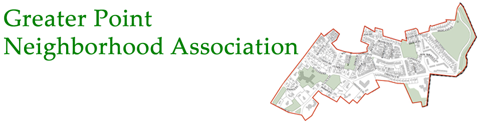
The association area is bounded by Boylston Street (Route 9), Warren Street near the Brookline Reservoir, the Sargent Road Trust area, the Boston municipal boundary near Jamaica Pond, and the High Street Hill (Pill Hill) neighborhood. It is centered around the historic “Point” neighborhood along Cypress Street, and includes adjacent residential areas also lying within Precinct 5 and the Lincoln School district. Landmarks include the First Parish Church, Lincoln School, the Brookline Music School, Kurkman’s Market, the former town garage and old Sewall School, Goddard House Assisted Living, and the Brookline Housing Authority’s High Street Veterans housing complex.
The Greater Point is a dense, walkable residential neighborhood with distinctive local businesses and convenient access to public transportation. Its settlement pattern was established in the nineteenth and early twentieth centuries, when the Point was a predominantly Irish-American area where many residents worked in domestic service, the trades or for the Town. Houses built in this period include three-families, as well as other multi-family dwellings and small cottages, many of them covering most of their building lots. Most of the buildings from this period are still present, in part because the Zoning By-Law, enacted decades later, requires greater setbacks and a lower floor-area ratio for new construction. Consequently there are fewer residential tear-down projects in the Point than in other, less densely-settled, parts of Brookline.
Complementing its residential density, the Greater Point boasts an array of beautiful and well-used parks and open spaces. They include the Old Town Green, the Lincoln School grounds, the historic Old Burying Ground, Clark Playground, Robinson Playground, Harry Downes Field, and the Babbling Brook section of the Riverway. Some of these open spaces tell the neighborhood’s history: the Lincoln School grounds was previously the site of the Park School, and before that the Kennard estate; Clark Playground was a commercial nursery with greenhouses; Robinson Playground was a car barn for the streetcars that ran down Cypress Street from Boylston Street (and the extra width of that section of Cypress Street allowed, in 2012, the installation of new bicycle lanes in each direction).